On Sunday, the IMD had said the “very severe” cyclonic storm “GATI” over the southwest Arabian Sea has moved westwards.
India Meteorological Department (IMD) informed on Monday stated due to well-marked low pressure over southwest Bay of Bengal, a cyclonic storm is expected on the Tamil Nadu-Puducherry coast in the next 24 hours.
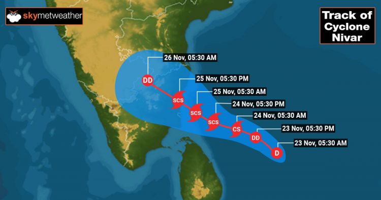
“The well-marked low pressure over southwest Bay of Bengal is very likely to intensify further into a cyclonic storm during next 24 hours and move towards Tamil Nadu-Puducherry coast.
It’s likely to cross between Karaikal & Mamallapuram by November 25 afternoon,” said S Balachandran, IMD Chennai.
“Very severe cyclonic storm ‘GATI’ over the southwest Arabian Sea moved westwards and lay centred over the southwest Arabian Sea near Latitude 10.4° N and Longitude 51.5°E, about 40 km east of Somalia coast & 90 km south-southeast of Ras Binnah (Somalia) at 1730 hrs IST today,” IMD had tweeted.
“The well-marked low-pressure area over southwest and adjoining southeast Bay of Bengal persists. It is very likely to concentrate into a depression over Southwest Bay of Bengal during next 12 hours and intensify further into a cyclonic storm during subsequent 24 hours,” IMD added.
In anticipation of the storm, the Met has issued a pre-cyclone watch and heavy rainfall warnings in districts such as Thanjavur, Tiruvarur, Nagapattinam and Karaikal over the next 24 hours.
Following the cyclone warning issued to the state by the Meteorological department, the Tamil Nadu State Disaster Management Authority (TNSDMA), issued warnings to fishermen to not venture into the sea till November 25.
The agency said high tides might reach a height of up to 18 ft at seashores in northern Tamil Nadu and 9.8 ft in southern TN.
On November 24, districts like Pudukkottai, Thanjavur, Tiruvarur, Karaikal, Nagapattinam, Cuddalore, Ariyalur and Perambalur can expect extremely heavy rainfall
While Chennai, Ramanathapuram, Sivaganga, Tiruchy, Kallakurichi, Villupuram, Puducherry, Kancheepuram, Tiruvallur, Ranipet, Tiruvannamalai, Tirupattur and Vellore districts will see very heavy rainfall.
On November 25, districts like Cuddalore, Kallakurichi, Puducherry, Villupuram, Tiruvannamalai, Chengalpattu to Ariyalur, Perambalur and Karaikal will receive extremely heavy rainfall.

The name Nivar is as per the suggestion from Iran and will be the third name to be used from the new list of names for North Indian Ocean Cyclones, released in 2020. WMO guidelines stipulate that the countries in the region must name storms in any ocean basin.
For the north Indian Ocean, that includes the Arabian Sea and the Bay of Bengal, thirteen countries suggest the names, including India.
If the Cyclone Nivar follows the projected path, it will be the first cyclone to hit Tamil Nadu in two years, since Cyclone Gaja on November 16, 2018.
The Very Severe Cyclonic Storm Gaja killed more than 50 people in Tamil Nadu, after making landfall in Nagapattinam. Nivar will be the fourth cyclone over the North Indian Ocean this year.
Cyclone Amphan killed 72 and millions affected , Modi 1K Cr package upsets Mamata


